EL1-155 - Gravity Map Matching
DESCRIPTION
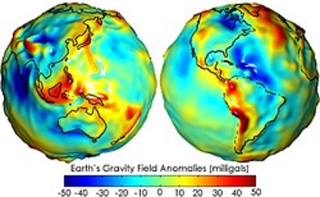
Due to the shape and composition of the Earth’s crust, each location in 3D space has a unique “gravity fingerprint”, given sufficient sensitivity. Space missions such as ESA’s GOCE have enabled the creation of gravity maps with an accuracy of 10-5 m/s².
Quantum sensors that can measure the gravity field with exquisite accuracy, together with recent advances in AI software that enable the removal of measurement noise, can allow the determination of location and navigation on land, in the air, at sea and underground, for manned and autonomous platforms. A particular focus is gravity-map generation to aid navigation with classical IMUs.
A quantum-enhanced gravimetric navigation system offers a passive, weather-independent and manipulation-proof backup to GNSS. Large-scale deployment of gravimetric sensors could also help produce better gravity maps for future resilient navigation.
The objective of the activity is the definition, implementation, and validation of a Gravity Map Matching navigation system.
The tasks to be performed shall include:
- Develop or select a high-performance gravity-measurement device based on quantum principles.
- Define and validate methods for determining location using a gravity map.
- Determine, through simulation, methods for updating the gravity map using measurements obtained by several devices in operation.
- Literature review and requirements: Review classical and quantum gravity sensors, including SWaP-C, performance, operational constraints, stabilisation requirements, dynamic range and ITAR constraints.
- Review techniques for making gravitational measurements from moving platforms.
- Review algorithmic techniques for converting raw gravity measurements into a map.
- Determine the requirements for a gravity map to aid classical inertial navigation in at least one operational environment.
- Concept and design: Select an operational environment and define a high-level architecture for generating a gravity map.
- Determine through simulation the improvements obtained by using several field devices and AI/ML processing methods.
- Build: Procure and integrate the required components into a demonstration system.
- Test: Conduct a field trial, generate a gravity map over a representative area and compare the data with the standard gravity model used in INS.
The main outputs of the activity will consist of:
- Simulation-framework definition, test scenarios and validation results.
- Prototype equipment.
- Recommendations for integration into next-generation GNSS/INS designs.
- Commercialisation roadmap providing a pathway to NAVISP EL2.
It is noted that Austria expressed their opt-out for this activity (EL1-155).