
Detect interference from orbit on a wider scale
Last Updated: 17/01/2023 14:30 Created at: 17/01/2023 13:00
Final Presentation of NAVISP Project EL2 117 now available:
On Friday 13, 2023, Spire Global UK Ltd presented the results of the NAVISP project “GNSS Interference Monitoring from LEO”. About 120 people from industry and research followed the interesting presentation and the subsequent interactive Q&A session, demonstrating the great interest in this important topic.
GNSS signals are vulnerable to interference, which can cause severe degradation or interruption of PNT services. Precise detection and geolocation of interference sources is an important capability allowing to proactively mitigate the interference. Current technologies to detect, identify and locate interference primarily rely on ground systems or aircraft and are not practical at global/regional scale. A LEO constellation of nanosatellites for GNSS jamming detection and geolocation offers numerous benefits, providing regular, cost-effective, and wide area coverage monitoring, that can be used to guide more accurate localised monitoring and mitigation activities, if applicable.
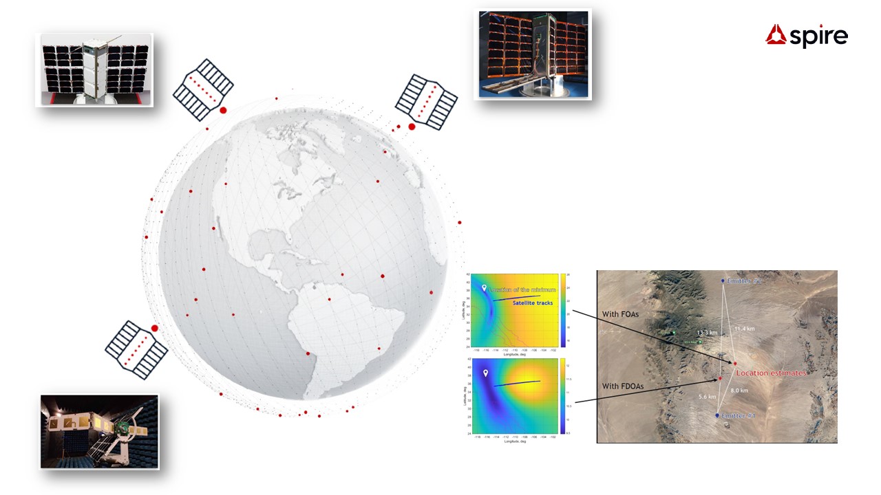
Therefore, the objective of this activity was to demonstrate that Spire’s existing GNSS Earth observation satellite technology can be harnessed to survey the terrestrial GNSS Radio-Frequency (RF) interference environment, detect uncooperative RF interference, and geolocate the source of these RF interference signals. Specifically, to date, Spire operates more than 40 active GNSS reflectometry (GNSS-R) and GNSS Radio Occultation (GNSS-RO) satellites equipped with Spire's STRATOS scientific GNSS receiver, which processes GNSS signals for precise satellite orbit determination (POD) and remote sensing. Payloads with STRATOS can be tasked with raw IF data collection to perform RF spectrum monitoring in L-band: this capability has been exploited to demonstrate proof-of-concept GNSS interference monitoring from LEO. By leveraging Spire's existing space assets, GNSS interference detection and geolocation of LEO nanosatellites could be demonstrated, adding significant value at low cost without requiring dedicated satellite launches. During the project phase, the following milestones were achieved:
- Scheduling process of IF data collections with Spire GNSS-R/RO satellites
- Design of algorithms for detection of different types of GNSS interference
- Design of algorithms for SSG (Single Satellite Geolocation) and MSG (Multiple Satellite Geolocation) of interference sources
- Evaluation of theoretical MSG precision based on Cramer-Rao Lower Bound (CRLB)
- Experiments for SSG and MSG accuracy estimation with data collected over known interference sources
With support of NAVISP, Spire was able to lay the foundation for the development of a low-latency PNT situational awareness service on a global scale by demonstrating the ability of Spire's Earth Observation assets to enable monitoring of GNSS interference sources in localized areas.
As a next step, Spire aims to build RF geolocation services with a dedicated development path, leveraging the global coverage enabled by GNSS-R/RO satellites and further pursuing RF intelligence in bands such as VHF, UHF, S-band, X-band as well as L-band.
The project was part of NAVISP Element 2, which aims to maintain and improve the capabilities and competitiveness of the participating States' industry in the global market for satellite navigation and, more broadly, PNT technologies and services.
More detailed information can be found in the slides of the Final Presentation.