
Navigating the sea: A partnership between Space and Water
Last Updated: 18/11/2022 11:52 Created at: 18/11/2022 11:34

Satellite navigation, or more generally position, navigation and timing data, has for years influenced and transformed developments in the maritime transport sector to increase efficiency and safety. To further support and accelerate this transformation, ESA’s Navigation Innovation & Support Programme (NAVISP) is supporting a project aimed at developing vessel mooring assisted guidance, using innovative satellite tracking technologies to support the latest generation of automation systems installed on board of ships.
Maritime transport is indispensable and the backbone of the international trading system and our economy, as the vast majority of all goods between Europe and overseas are transported on large vessels. Globally, more than 80% of the international volume of goods is transported by sea, with an upward trend: between 1990 and 2015, maritime transport increased by more than 150%, demonstrating the growing importance of the sector. Consequently, the efficiency of ports has a direct impact on the economy of the countries they serve. At the same time, associated challenges need to be addressed, including the impact on the environment.
The United Nations International Maritime Organization  (IMO) set an ambitious target for maritime transport in 2018: to cut the CO2 emissions of maritime transport by 40% by 2030 and greenhouse gas emissions by 50% by 2050, both compared to a base year of 2008.
With a coastline of 8,700 kilometres and its strategic location in the Mediterranean Basin, Italy is the third largest “blue economy” in Europe and thus holds an important position within Europe to achieve the IMO goals. The entire blue economy, with Maritime transport as the most important segment, generated over $145 billion in 2021, equivalent to 10% of Italy's GDP, with more than 225,000 companies employing over 900,000 workers. In addition, the post-pandemic redefinition of some supply chains at regional level will bring some sectors back to Europe, which could further stimulate the growth of short sea shipping, where the Mediterranean already holds a leading position in Europe. The importance of the maritime sector and the sea was recently highlighted by the establishment of the new Italian Ministry for Sea Policies and the South.
 The Naples-based Grimaldi Group, as one of the largest international shipping groups, with a fleet of around 130 ships owned, 10 newbuilds under construction and 10 in the design phase, is supporting the development towards a more sustainable more efficient maritime transport and port management. With the support of the Italian Space Agency (ASI), the Grimaldi Group was awarded the GSAB (Grimaldi Satellite Assisted Berthing) project, funded by the European Space Agency, to develop and validate the first satellite-based guidance system for docking manoeuvres of large PCTC (Pure Car & Truck Carrier) vessels.
”The project is divided into two Phases. The current NAVISP activity covers the design and development activities, the installation of the sensors in a Ro-Ro vessel, and a test readiness campaign. In the second phase, field tests will be executed with the equipped ship in the Grimaldi facilities at the Antwerp Terminal”, adds Felix Toran, the System Engineer, overseeing the project for ESA.
Grimaldi will coordinate an international team with the Norwegian company Kongsberg, industry leader and developer of signal reception and processing technologies, and the Radiolabs consortium, which will not only support the Grimaldi Group as prime contractor but also take care of the design, execution and validation of the system under operational conditions. The operational tests will be carried out on one of the large and modern ro-ro ships part of the Neapolitan shipping group’s fleet. “We believe in the potential of the GSAB project being the first project in this field grouping together a competent team with the maritime operator, a system provider and a research entity specialised on high integrity positioning. The vision is to leverage on GSAB to target the future autonomous berthing capabilities employing a big ship that represents a premiere for the testing phase,” explains Cosimo Cervicato Senior Executive Engineer from the GRIMALDI Group.
Specifically, the project is funded under ESA's Navigation Innovation Support Programme to help the international consortium develop a product that enables efficient, sustainable and safe maritime traffic and port management through the innovative use of position, navigation and timing (PNT) data. “Maritime operations in ports are very demanding in terms of navigation performance, that cannot be met by GNSS alone. It becomes crucial to fuse GNSS with other PNT sensors, in order to achieve the required performance levels to allow this kind of operations.” says Felix Toran.
Tasks related to the use of PNT information include, for example, planning and determining the position and movement of a vessel as well as monitoring the vessel in relation to its surroundings, e.g., to support collision avoidance. Furthermore, PNT information enables automated or semi-automated control and regulation processes on ships and in ports, including efficient berthing, thereby increasing the overall efficiency of processes.
Navigation in coastal areas as well as mooring in harbours is 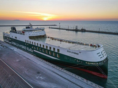 particularly challenging due to the high requirements for accuracy and reliability with limited reception conditions at the same time. In addition to these safety-critical challenges, operational and economic aspects of the shipping business and the sustainable development of ports also increasingly depend on the use of PNT data. In this context, GSAB will makes use of the latest innovations on satellite-based multi-sensor technologies, which will contribute to improve the efficiency of manoeuvres in the port and this increase the safety while reducing CO2 emissions in line with the strategy of a greener and safer maritime transport as well as the ESA accelerator “Space for a green future.” Cosimo Cervicato explains: “Increase of capacity, safety and reduction of pollution – that are the main drivers for sustainable maritime operations and ports. Autonomous berthing represents the next frontier for optimising maritime operations and to increasing the efficiency of the ports.”
“Implementing an assisted digital system for navigation in port waters and for berthing manoeuvres for RORO and CARCARRIER ships has several advantages for the automation of port manoeuvres, the transport efficiency and also for the reduction of CO2 as for example the automatic execution of operations with the highest level of autonomy compatible with current technologies; the time saving with the reduction of the tugs needed and more efficient vessels behaviour in ports; Better in-port situational awareness on the state of the ship and the context in which operates (wind, current, seabed, ship traffic, ...), with the goal to optimize the manoeuvres.”
Felix Toran, Technical Officer of the project adds: “Many ports cannot allow access to large ships, which number is rapidly increasing. The GSAB system will support safer and faster manoeuvring and docking by allowing large ships access to these ports. This would result in a possible increase in traffic and the possibility of accepting Lines Operators that currently follow other routes, thus obtaining an increase in their commercial volume.”
In other words, with GSAB, Grimaldi will be able to leverage its expertise and capabilities to assess real-time berthing capacity with GNSS and the accuracy required for collision avoidance, while supporting and accelerating the development towards more efficient and sustainable ports.
For the ESA article on this topic, please click here.