
Positioning and guidance box for autonomous robots
Last Updated: 13/07/2023 09:08 Created at: 13/07/2023 07:34
Final Presentation of NAVISP Project EL2 088 now available:
On Monday, July 3rd, 2023, Agreenculture presented the results of the NAVISP EL2 088 project "AGC Box - Positioning and guidance box for autonomous robots". About 50 people from industry and research institutes followed the interesting presentation and the subsequent interactive Q&A session.
To mitigate carbon emissions, the agricultural industry is embracing sustainable practices. With a decrease or even prohibition of chemical usage, farmers are turning to mechanical weeding as an alternative. However, this method is time-consuming, requiring farmers to make multiple passes each month. As a result, autonomous vehicles are being more and more employed to assist farmers in accomplishing necessary tasks on their farms.
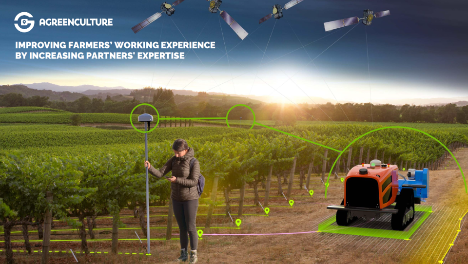
Satellite based Positioning, Navigation and Timing (PNT) data presents numerous opportunities, but not all the solutions available in the market are suitable for the evolving agricultural environment. In this context, AgreenCulture developed a positioning and guidance box named AGCBox, designed for agricultural autonomous robots with geofencing characteristics and several functionalities that can be added. The AGCbox incorporates a custom-built RTK algorithm to achieve precise measurements within centimeter accuracy, ensuring safety in agricultural settings. The box seamlessly integrates with robotic systems, offering users a smooth and hassle-free experience. Through a simple connection to the robot's CAN bus, the box assumes control over the motors responsible for tracks/wheels and agricultural implements.
By using PNT information based on GNSS satellite data, the AGCbox can easily determine the exact position of the robot. It also serves as a reference station, eliminating the need for GNSS correction streams. For added flexibility and convenience, the AGCbox can be mounted on a survey pole to perform tasks like land surveying and outline definition. It facilitates seamless data transfer and communication with cloud services, allowing collected data from the field or land surveying to be easily transferred and utilized by farm management software. Furthermore, a geofencing mechanism known as 'Safencing' has been developed, which relies on the positional integrity. This mechanism allows the robot to immediately halt its operation whenever there is any uncertainty about its position. The integrity factor plays a crucial role in ensuring precise weeding without causing harm to either the crops or individuals located outside the designated area.
At the end of the project, the company introduced its product to the market and achieved initial sales, signalling a promising start.
The project was part of NAVISP Element 2, which aims to maintain and improve the capabilities and competitiveness of the participating States' industry in the global market for satellite navigation and, more broadly, PNT technologies and services.
More detailed information can be found in the slides of the Final Presentation and in the video.