NAVISP INDUSTRY CALIBRATES GNSS RECEIVERS WITH HELP FROM THE AIR. PLEASE REGISTER FOR THE FINAL PRESENTATION OF THE ELEMENT 2 PROJECT "A NOVEL SOLUTION TO VALIDATE GNSS RECEIVER FOR AUTONOMOUS DRIVING"
Start date: 18/01/2022 10:00
End date: 18/01/2022 11:30
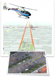
The goal of the NAVISP Element 2 project "A NOVEL SOLUTION TO VALIDATE GNSS RECEIVER FOR AUTONOMOUS DRIVING" (VaGAD) is to develop a new method for calibration and validation of GNSS receivers in the automotive industry for Level 3 and Level 4 of automation under real world conditions. The method uses simultaneously acquired high-resolution aerial image
data from a helicopter which are precisely georeferenced with Ground Control Points. The images show the vehicle roof with the signalized GNSS receiver antenna. Together with a precise height model of the road surface, the absolute position of the GNSS receiver in world coordinates can be derived from the position in the image. The method aims to provide high-precision reference trajectories in all environments, including GNSS-denied ones, to facilitate the calibration and validation of positioning systems for autonomous driving.
Please register to the Final Presentation to learn how the VaGAD method was put into practice as part of a test campaign in July 2021.
Please follow the links to the Agenda and to the event registration.

