
SSRoverDAB+: TRANSMISSION OF HIGH-ACCURACY GNSS CORRECTIONS VIA DAB+
Last Updated: 13/07/2023 07:16 Created at: 13/07/2023 07:08
Final Presentation of NAVISP Project EL2 069 now available:
On Tuesday, May 30th, 2023, the consortium consisting of the companies Alberding GmbH, Fraunhofer IIS, Geo++ GmbH, inPosition, BayWa AG, The Federal Agency for Cartography and Geodesy (BKG) and the Bavarian Agency for Digitisation, High-Speed Internet and Surveying (LDBV) presented the results of the NAVISP EL2 069 project "SSROVER DAB+". Over 30 people from industry and research institutes followed the interesting presentation and the subsequent interactive Q&A session.
The rapid emergence of digitalization and automation in agriculture and automotive sectors has generated an insatiable need for precise, real-time GNSS positioning information that can be accessed ubiquitously. However, limited cellular mobile internet access in certain regions forces farmers to rely on costly commercial PPP or PPP-RTK corrections disseminated through geostationary satellites, resulting in higher exploitation cost and in some cases lower reception reliability. Nevertheless, the landscape is evolving as GNSS correction services make the transition from traditional Observation Space Representation (OSR) to advanced State Space Representations (SSR). This paradigm shift brings a host of benefits, including reduced bandwidth requirements and the ability to optimize data transmission through unidirectional broadcast media like digital radio and satellite systems, in addition to the internet. By embracing SSR, farmers gain flexibility, scalability, and performance comparable to classical NRTK services such as PPP-RTK, along with the advantage of backward compatibility through the conversion of SSR corrections to OSR.
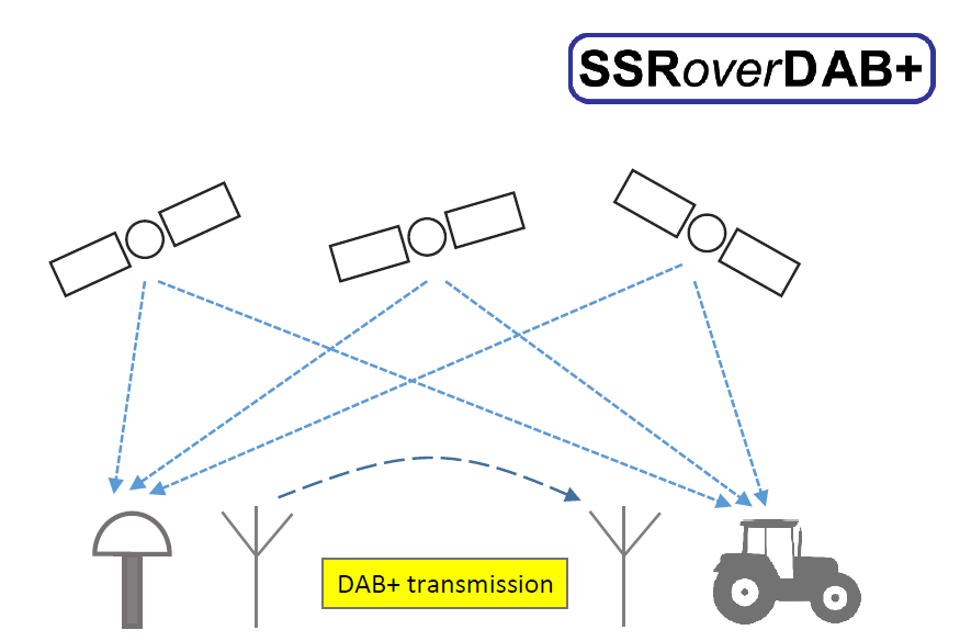
The "SSRoverDAB+" project aims to provide high-accuracy GNSS positioning with the generation of precise SSR corrections and its transmission through the public Digital Audio Broadcasting (DAB+) network. By developing innovative algorithms and formats for unidirectional communication, it eliminates the need for bidirectional data transfer required by VRS technology. The project leverages the optimal fit between the SSR standard and the new digital radio transmission technology DAB+, which boasts a 98% coverage in Germany and can be received for free using affordable standard hardware components. A key focus is on adapting and developing a GNSS RTK sensor capable of receiving free governmental RTK corrections through cellular mobile internet, while also incorporating highly available SSR corrections via low-cost DAB+ broadcast. This integration ensures fast convergence for RTK positions, enhancing the overall precision of the system. Leveraging the expertise of Geo++ GmbH and Fraunhofer IIS, successful data transmission is enabled through the DAB+ infrastructure. Alberding GmbH designed pioneering mobile sensor hardware integrating GNSS, DAB+, mobile internet, inertial measurement units, and processing power. The project also focuses on standardizing SSR protocols and data formats, developing precise positioning and sensor fusion algorithms, and evaluating E5AltBOC with SSR corrections.
In conclusion, the next steps for product development involve the creation of a smaller form factor DAB receiver module for system integration, a new Alberding sensor platform with increased processing power, and the development of a DAB+ antenna solution for mobile applications. Additionally, the production of second-generation hardware prototypes in higher volume, expanding testing to more participants, and creating a highly integrated board for end users and system integrators are crucial. These developments aim to meet the requirements of an open data SAPOS PPP-RTK service in Germany, provide precise SSR corrections via the DAB+ data channel, and cater to potential markets in various industries such as agriculture, automotive, and geodetic applications.
The project was part of NAVISP Element 2, which aims to maintain and improve the capabilities and competitiveness of the participating States' industry in the global market for satellite navigation and, more broadly, PNT technologies and services.
More detailed information can be found in the slides of the Final Presentation.