
334 - OCULIZE
Status: On Going
Activity Code: NAVISP-EL2-334
Start date: 07/07/2026
Duration: 18 Months
The Luna Systems OCULIZE project aims to improve micro-mobility safety through the development of a dedicated AI-enabled camera platform for cyclists, capable of providing real-time proximity alerts and generating high-precision urban safety maps. The solution will enable the creation of geo-referenced 3D digital safety twins of cycling infrastructure by combining on-street image capture, machine vision, SLAM processing, and PPK-corrected GNSS positioning data to achieve decimetre-level localisation accuracy.
Building upon the existing Luna Oculus beta platform, developed outside this activity, OCULIZE will transition key processing capabilities from a smartphone-dependent architecture to a dedicated embedded hardware solution integrated directly within the Luna camera device. The project will develop advanced embedded firmware and AI processing pipelines capable of identifying road hazards, traffic encroachment events, unsafe overtaking behaviour, and critical streetscape features within contextualised 3D safety maps.
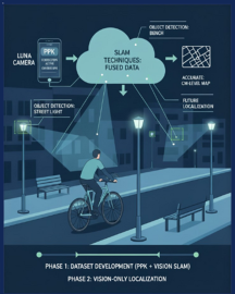
The proposed solution leverages raw GNSS observations captured from Android OS 10+ smartphones supporting L1/L5 measurements, enabling high-accuracy positioning without requiring expensive RTK hardware. Data collected from “Pathfinder” high-mileage cyclists will be used to establish baseline “Safety Digital Twin” maps of urban cycling routes, allowing municipalities and infrastructure planners to identify accident hotspots, assess cycling infrastructure quality, and prioritise remediation activities using near real-time environmental intelligence. The project will facilitate “vision-only” localisation and navigation.
In parallel, the project supports the development of a scalable cyclist safety product for consumer and OEM bicycle markets, combining advanced rider awareness, infrastructure analytics, and community-driven mapping into a unified micro-mobility safety platform.
In summary, the OCULIZE project delivers a low-cost, edge-AI cycling safety platform that synchronizes on-device machine vision perception from a Sony IMX500 sensor with raw L1/L5 GNSS observations from a paired smartphone. By fusing this data through cloud-based Post-Processed Kinematic (PPK) pipelines and vision-SLAM algorithms, the system achieves sub-meter positioning accuracy to generate dynamically updating infrastructure "Digital Cycling Safety Twins" while bypassing the need for expensive on-bike RTK hardware.

Last Updated: 06/07/2026 07:21