
Development and Demonstration of a Navigation Support System for Assisted Berthing of Large Car-Carrier Ships
Last Updated: 28/05/2024 06:56 Created at: 28/05/2024 06:56
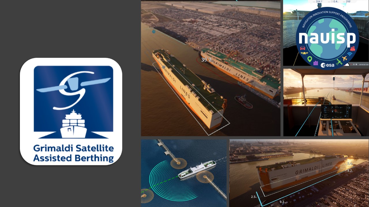
Final Presentation of NAVISP Project EL2-122 now available:
On Wenesday, May 15th, 2024, Grimaldi Euromed S.p.A. in partnership with Kongsberg Seatex (Norway) and Radiolabs Consortium presented the results of the NAVISP EL2-122 project "Grimaldi Satellite Autonomous Berthing (GSAB)”.
As maritime operations evolve, the need for advanced technologies to enhance safety, efficiency, and environmental sustainability becomes paramount. The Grimaldi Satellite Assisted Berthing (GSAB) project is a pioneering initiative focusing on the domain of assisted and autonomous shipping, particularly in the proximity of seaports. The project is dedicated to developing and demonstrating a navigation support system that facilitates the high-precision berthing of large car-carrier ships (200m in length) paving the way to autonomous berthing.
In this context, the primary goal of the GSAB project was to automate high-precision berthing operations using advanced PNT technologies tailored for autonomous ships. Central to the project was the design and development of the GSAB system, which integrates a variety of sensors and processing capabilities to provide real-time advisory support to operators through traditional electronic chart surfaces (ECDIS) and a 3D augmented reality platform. A key component of the system is the inertial navigation system (INS), which combines GNSS measurements with motion and attitude data to offer precise information on vessel location, velocities, and acceleration. Additionally, cameras were used to measure steel-to-steel distances and distances to quaysides or other obstructions. The onboard sensor system features an image segmentation neural network that processes camera data to differentiate between open waters, land, quays, and other floating objects. By fusing these camera measurements with INS data, the system generates accurate metrics for steel-to-steel and distance-to-quay measurements. Over time, an internal map of the surroundings is built through continuous camera and sensor input.
In the future the system will equip the captain and crew with a comprehensive, real-time overview of the ship's conditions and the port context, including precise indications for manoeuvring operations. Furthermore, the system is designed to improve ship efficiency by reducing the time required for berthing manoeuvres and to lower fuel consumption, thereby reducing CO2 emissions in the port area.
In conclusion, the GSAB project, aimed to revolutionize port navigation and berthing processes for large car-carrier ships. By integrating advanced sensors, real-time data processing, and augmented reality visualization, the project sought to enhance safety, efficiency, and environmental sustainability in maritime operations. This initiative set new standards in the latest PNT technologies within the maritime domain and showcases the commitment of key stakeholders. The project is currently continuing as GSAB2, which will build on the results of this project to advance the technology to autonomy level 2, with the potential to reach autonomy level 3 in the future.
The project was part of NAVISP Element 2, which aims to maintain and improve the capabilities and competitiveness of the participating States' industry in the global market for satellite navigation and, more broadly, PNT technologies and services.
More detailed information can be found in the slides of the Final Presentation.